All posts by Dulany Sriner

New Christmas Cameras

I don’t remember the statistics, but more and more people are taking digital photographs than ever took pictures before. This Christmas should increase that number significantly. Here are five of the most important tips for new digital photographers.

1) Many of the cheap film cameras had fixed focus lenses. That means the lens was designed to capture subjects from about 5 feet to infinity, depending on the lighting. As long as the conditions were just right, they could take great pictures. But the newer digital cameras are usually better quality and they focus the lens from close up to far away. For these cameras, there is normally a two position button. When you depress it 1/2 way down, it focuses on the subject and then when you press the rest of the way, it opens the shutter and takes the picture. With the old cameras, you just press the button and almost instantaneously, the picture is taken. If you do the same thing now and press the button all the way down there is a lag time between pressing the button and taking the picture. If you press the button without giving it a chance to focus, it is often taking the picture while you are moving the camera for the next shot. If you find yourself chopping off heads or getting blurred pictures, this is probably the problem. Steady the camera, press the button 1/2 down to focus (usually there is a red dot or a beep when the picture is in focus) then press the button the rest of the way and hold the camera still for a couple seconds to be certain the shutter is finished opening and closing.

2) If your camera has a view window for composing the picture rather than a viewfinder, try to hold the camera close in to limit camera movement. If you move the camera while it is taking the picture, it will blur. If you are zoomed in on something the potential for blurring is increased. If your camera has both a viewfinder and a screen, it is best to use the viewfinder because keeping the camera pressed against your face will held to keep it steady. Holding the camera at arms length, makes it difficult to keep the camera steady. The image stabilizers will help but can’t control it completely especially if you are in dim light of zoomed in.

3)The flash memory supplied with most cameras is usually minimal. The low capacity often will force you to reduce the picture quality to be able to take more pictures. This hurts in two ways. The reduced capacity forces you to take fewer pictures and often pushes you to set the picture quality to lower settings either by reducing the number of pixel’s in the picture and also in reducing the quality of the compression. I recommend setting the number of pixels to the highest number. Why get a 6 mega pixel camera and set it to record less than 2 mega pixels.

4) Digital zoom is worthless because it doesn’t actually zoom in on a subject, it actually just cuts away some of the extra background. The quality is reduced. If you digitally zoom in on something to make it twice as big, you actually reduce the number of pixels to 1/4. This fact is not true of the optical zoom. If you zoom in to an object to make it twice as large, the original number of picture pixels is the same as without the zoom.

5) Digital cameras can’t see contrast as well as your eyes can. If you look at someone in a shadow on a sunny day, you can see the bright portion of the sky and the shadow portion of the subject. The camera can’t. If it sets itself to capture the bright sky, the shadows will all look too dark to see anything. If you set the camera to picture the parts in the shadow, the sky and rest of the picture will be so bright they will wash out. So, even on a sunny day, you might need a flash to show faces in the shadow. It is probably needed more outside to show faces than inside where there is less contrast.

Two hours to kill

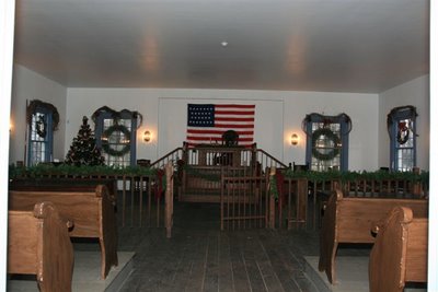
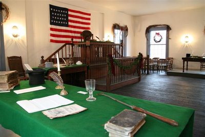
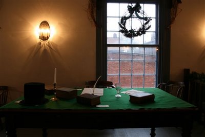
After dropping Pat off at a baby shower in the rural countryside near Metamora IL, and knowing I had two hours to kill before returning to pick her up, I headed to the historic small town of Metamora. Driving down the main drag, I saw a brown sign, which is a starting point for many of our adventures. It was pointing to the Metamora Court House Historic site which sits on the north side of the city square. The building was built in 1845 for the Eighth Judicial District. After the county seat was moved from Metamora, the building spent a short time as an opera house but in 1921 renovation began to turn it into the museum it is today. The first floor is devoted to local memorabilia and the second floor is the restored courtroom.

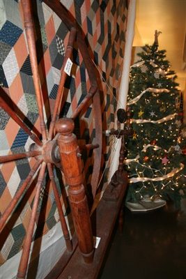
 In keeping with the Christmas season, decorated trees were found throughout the building.

I could almost feel Lincoln’s presence as I rounded the top of the steps and moved back in time. As I walked in, I stepped on the same flooring Abe must have paced as he argued more than 70 cases including two harboring slave cases and two murders. During one murder case, his client on trial for murdering her wife-beating husband was said to have asked him where she could get a good drink of water. He told her “Kentucky” and when the court recess was over, she was nowhere in sight.
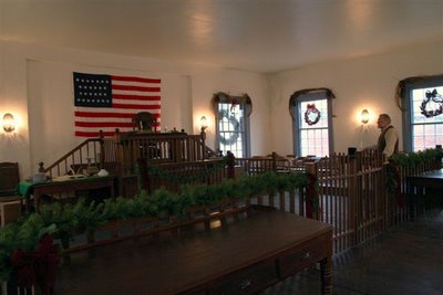
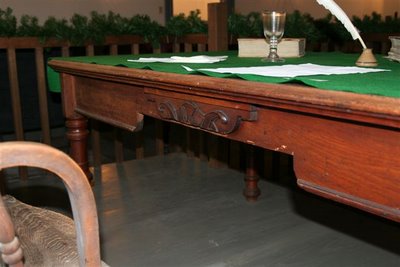
The site Manager, Jean Myers, stands in the witness box. This was an English style court and the witness was to remain standing throughout the testimony. A spitbox was on the floor to his left because for a witness to be heard and understood, he must have an empty mouth devoid of any chewing tobacco. The above desk was once used by Lincoln and because of his long legs, a section was cut out for his comfort. The picture below shows that cut out section.
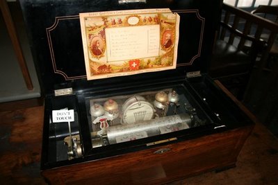
This musicbox is a larger version of one referred to in the Lincoln Presidential Museum as belonging to Lincoln’s wife. I listened to it plan and it was as beautiful to hear as it was to see. So, if you find yourself with a couple hours to kill and Metamora is close at hand, I highly recommend a visit to the site. Tell Jean you saw it on the Em-T-nest Blog and perhaps he will let you listen to a tune similar to one Lincoln might have heard coming from his wife’s music box.

With darkness fast approaching, I picked up Pat and we headed into E Peoria to view for the first time, the Festival of Lights. But that will have to wait for another post. Come back and see a blue whale ready to devour the city of Peoria.

Home coming at SIU

The nest is empty –
We must be on the road again!

We were about 30 miles down the road before I realized something was missing. We were driving blind as we had left the laptop at home and this was a 3 day weekend. If you have read the article on the GPS below, you saw how large it was and you might ask, “How could you forget or at least not notice the absence of the laptop?” As any good politician would say, “That’s a good question.” and then there would be some long dissertation on some irrelevant situation before moving to the next question. Well, I’m no politician and I say that proudly especially after this election. I was brought up to tell the truth; so to answer your question, ” I’m 60 years old; my hearing isn’t what it used to be so I didn’t notice the missing hum from the blower. My eyesight is not the eagle eye status it was when I first traveled these roads so I just didn’t notice the now visible radio and heat controls. And, well I hate to admit it but I suspect a slight downturn in brain matter replacement. Did I mention I turned 60 this year. Now, what was the question?

I knew we didn’t need the mapping aid for the trip down to SIU because since my daughter’s recent transfer to the school we have made 4 – 5 trips down. We had to check it out before she signed up; we had to go down for her to sign up and we had to take her down with a full load of necessities. It was certainly a full load. She had her car packed as did we. Pat and I moved less to our new apartment in Chicago when we got married. To give you an idea of a time line here, the “old route” 66 signs were referring to the road we were on. Did I mention , I was 60? Next, we had to take down a new refrigerator because the one she rented was “nasty” as she put it. Now you might think this was the end of our short trips to Southern Illinois but you would be wrong because the dorm didn’t work out and a move to an apartment off campus was next on the agenda. Of coarse, that required additional “supplies” like furniture. Now I have lost count but you get the picture.
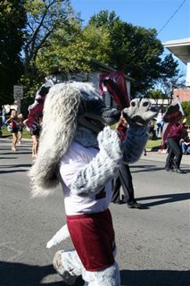
The trip down was rather uneventful and we didn’t miss the GPS. The first night, we stayed in a cabin at Giant City State park. That was nice and I would do that again. We took a few pictures in the park before heading into town for the parade.
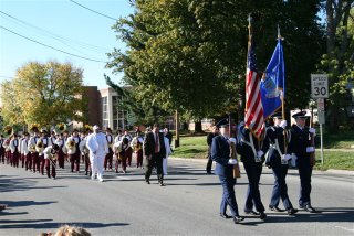
It was a beautiful day and there were some great school bands.

After a picnic in the Alumni tent, we headed into the stands for the game. It was fun to watch the kids and younger alum with all their excitement.


We looked at each other and wondered if we ever acted like that. Some how the back roads of Southern Illinois kept nagging at my brain. We made it until half time and took off.

We headed south toward Metropolis and made a stop at Ferne Clyffe State Park South of Goreville on Rt 37.
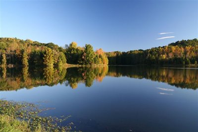
The lake there couldn’t have been more perfect. The reflection of the trees doubled the bright fall colors. It was spectacular. Our next stop was Mermet Lake on route 45 northwest of Metropolis. There we enjoyed the setting sun.
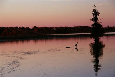
A lone great Blue heron was silhouetted against the reds of the setting sun.


The now dark road into Metropolis was a bit unnerving without the aid of our GPS but we made it to town and eventually found a vacancy at a Best Western. It turned out to be nicer and even less expensive than the Comfort Inn we stayed at during an earlier visit.
AS you might know, Metropolis is the home of Superman and while the downtown Superman attractions are a bit run down, it is still worth a stop for a picture. I pictured my wife standing underneath between his giant legs looking up at his gigantic . . . . . . I’ll leave this to your imagination.
Metropolis is also the home of Fort Massac State Park. We toured that on our last trip. This brings us to a close for the night. Tomorrow we will head along the Ohio river By Way toward Cairo the southernmost point in Illinois.

Morning brought with it another beautiful day and after a delicious breakfast at the motel, we headed southwest toward Cairo. The Ohio By-Way road took us along the river with an occasional vista to turn out and look over the valley. We made a stop at Olmstead to see the construction of a new lock and damn and on to Mound City to photograph the county courthouse. Pat wants to compile a book of all the county courthouses in Illinois. I only took one picture of it. That tells the story. It looked like an old school.
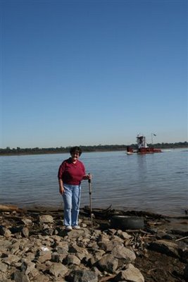
At right, you can see Pat standing on the southernmost tip of Illinois where the Ohio and Mississippi join and head for the gulf. Don’t tell anyone but I picked up a rock from the very end so the state is a little shorter now. Fort Defiance once stood here and the area is now set aside as a park. The park was rather run down but it was worth stopping just to say we had been to the tip!

At this location, the only way to stay in Illinois was to head north so now we followed the Mississippi River along the Great River Road to the north and west along Rt. 3 into the cache River reclamation area. We had visited this area early in the summer for a photo workshop and found it awesome. I never knew there was swampland in Illinois. You don’t expect to see cypress trees and green water here. We headed over to horseshoe Lake on the southwestern edge but if this is your first time down here, I recommend going to the Cache River Wetlands Visitors Center on route 37 due east of Belknap. From there you can get information about Heron Pond and other spots along this watershed. This would be east and north of our location at Cairo so we left that for a second visit at a later time. Horseshoe Lake is near the Mississippi, south of Thebes. Below, you can see one of the many beautiful sights. The road to the campground takes you around on the west side of the lake. It is quite a way back but well worth it. We will definitely go back there again.

It is so alive with vegetation, birds and bugs! You will want to carry your trusty insect repellent throughout this area.
This is a picture from around on the east side and repeated itself every time we saw a clearing.

We continued north to Thebes for the court house shot and it was very modern by comparison to most of the others I have photographed. Next stop on our itinerary was Chester, the home of Popeye. We bypassed Cape Girardeau to save time but in retrospect, we probably should have stopped there as there are many photo ops there. As it turned out, we wasted considerable time going over to Kinkaid Lake which turned out to be a waste of time.

AS we drove down an uneventful Rt 3, I saw a sign for some kind of wildlife ravine. It was around Cora as we crossed the corner of the Shawnee National Forest. It was a gravel road and remember we were without the GPS! We turned off onto Hog Hill Road. This gives you some idea of our surroundings. The road wound around and had several intersections and we were flying blind. I kept thinking we would see another sign. This road, and I use the term loosely, jigged and jagged and eventually made its way to Piney Creek Ravine State Natural area. Well, we made it but all it turned out to be was a small grass lot and a trail head. We were not looking to take a trail although it might have been beautiful so we planned our next itinerary. With the GPS it would have been so easy but with just a state map, we had no idea where we were. Rock Crusher Road went east; and Piney Creek Road went west or we could go back the way we came but I knew we had come quite a way north as I had been watching the car compass. I didn’t know how far east. Our next itinerary was Chester. I guessed it would be approximately due west so I took the Piney Creek Road. It would around, up and down and became more and more primitive. I was beginning to question my judgment. Just then we came around a curve and there on a bridge ahead we saw a truck parked and a backwoods Mom was there with two little boys playing with frogs near the stream. Fortunately it wasn’t the brothers from Deliverance. She looked like an angel to me. We stopped and asked where the hell we were and how to get to Chester. AS it turned out about a mile up this road we would intersect with the Chester blacktop. On my map program that I can now check, it is simply listed as County Farm Road. It wound around and eventually ended in Chester. We made it!
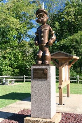
It was obvious Popeye got a lot more attention than Superman did in Metropolis. I took a few pictures for us and then offered to take a few shots for a motorcycle group touring.

By this time we were both adventured out and we hit the road home. No more winding Great River Road. We continued up Rt 3 to 255 and on to Interstate 55 north to Springfield. Home felt really good that night.

There are many more back roads to travel so come back often and join in as we take flight from the empty nest to see the roads less traveled.

See it; Take it!


A picture is an instant in time; frozen and captured forever. That picture is only available for that instant, then it is replaced by another instant ready for capture. I can remember sitting around a local lake club as a kid listening to the fishermen talk about the fish that got away. They were always the biggest and the best. Pictures are often like that too.

Have you ever seen a sunset that was more beautiful than you had ever seen before, but by the time you found just the right spot to stop and take a picture, it was gone. Sunsets are one of those fleeting moments. Sometimes you have to be content to just see it and enjoy the beauty but not capture it for everyone to see. This will be one that got away. You can talk about it to your friends, but all you have is the memory.

The sunset above didn’t get away. It was taken at Mermet Lake, a lake in Southern Illinois near the Cache River system.

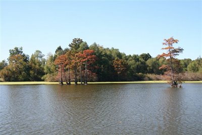
Above, we have a nice picture of a lake with some fall foliage on the shoreline. It certainly would not win any prize. 15 minutes earlier, it was a beautiful reflection picture. The lake was smooth as glass. I thought, “what a beautiful picture, I’ll be sure to get it on the way back. This is what I got on the way back! If you see a great picture, stop; go back, if necessary; and take the shot. It might not be there on the way back.

I remember another time walking up a long road at Allerton Park and just as we turned the corner, the now visible giant Sun Worshipper statue was upstaged by a beautiful deer standing silent in the middle of the road in front of us. In the excitement, I grabbed my camera and started exchanging my wide angle lens for the big telephoto so I could get the deer full frame. As I raised the viewfinder to my eye, the deer vanished into the woods. Why didn’t I just take the wide angle shot first and then change lenses. At least I could have had a lovely landscape with a deer prominently displayed. Here we had another fish that got away! This was a case of poor quick judgment; however, if he had stayed just a few seconds longer, I would have had a prize winner.

One of the advantages of digital photography is the availability of numerous shots. See it, shoot it. If you don’t like it later, no harm done. There is always the delete button, but I have not seen the camera yet that has a button to add a few more shots from different angles. All the equipment in the world is worthless until you turn it on and press the shutter button.

Other examples of the shot that got away are too numerous to note; but fortunately, I am listening to my own advice and it doesn’t happen nearly as often. We are turning off the main roads with their fast paced traffic. We are taking the roads less traveled in America’s back yard. If you would like to join us on our journeys, you can catch us at http://em-t-nest.blogspot.com/ . But before you try to follow, check out the article on GPS navigation on the em-t-nest blogspot. So, clean the dust off the sensor, buckle up and follow along.

GPS


Have you ever seen those disclaimers, “Don’t do this at home” or “this was done with trained drivers on a closed coarse.” ? These are my disclaimers. Don’t try to follow us down those roads less traveled without a mechanically sound vehicle, a full tank of gas and a quality GPS system. A cooler with drinks and snacks is also a good idea. You can see our set-up at left. We use a laptop computer with 2007 DeLorme Street Atlas software installed. I have tried a couple others but found this to be the best for our use; particularly the GPS features. We use the DeLorme GPS unit on the dashboard. It is about the size of a half deck of cards. You can see the edge of it just to the left of the screen on the dashboard. It is yellow. This software will zoom in enough to see all the included streets and their names. We have found streets that were nothing more than a slight depression across a field and on some occasions streets, and I use the term loosely, that are closed or no longer drivable. That is when I appreciate the 4 wheel drive and tight turning radius of my Jeep. As you can see, I have the opened laptop propped up in front of the shift levers on the console and leaning against the dashboard. I have velcro tape installed along the lower edge of the laptop to correspond to the other side of the velcro mounted on the console. This keeps the unit from sliding. The only real problem with this setup is that the screen covers the air vents and the lower portion covers the heat and A/C controls. I have to lean the unit back toward me to get to the controls. Every car will be different so you will have to test out the best positioning for you. I think a column shift would allow the keyboard to sit down on the console and only the screen would extend up. I will be thinking about this option on the next vehicle.

We didn’t realize how much we relied on the GPS until we forgot it one long weekend. We were at the mercy of torn folded maps and missing street signs. There is a loss of the feeling of security driving down a road that keeps getting narrower and less improved when you don’t know how far it is to the next county road or highway. You start getting that “Deliverance” feeling. This feeling is multiplied 10 times if it is getting dark or your gas tank is getting low! It is also nice to be able to go to the route tab and map a trip from where you are, noted as Current GPS position to “Home”. It almost instantly shows the distance and time to get home from where you are and the roads to take. In my next entry, I will describe the trip we took without it.

I have not had any experience with the new factory GPS systems but I suspect I would like the convenience of the factory installation and dash mounted screen but I don’t know if I would be satisfied without the large screen to see the broader picture of our road options and directions.

Welcome

Welcome to the new Empty nesters Blog space. When fully operational, we will fill this space with journals of our travels on the backroads of Illinois and beyond. While pictures will be our primary emphasis, they will be in context with the narrative to help bring them to life. Your comments will help direct our travels and give us feedback on what you would like to see. So clime in and buckle up because the roads less traveled are not always the smoothest ride. Dead end roads and washed out bridges are a common annoyance and often a memorable opportunity. It’s Saturday morning – where should we go?