Category Archives: Em-T-Nest

Eagles in winter

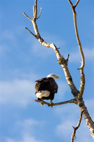
Winter around the Sriner household often revolves around the annual quest for the Bald Eagle. This year was no different.
 Click on the above and other pictures to see them full sized!

January of this year, brought with it a trip to the operating room for Pat. She had to have major shoulder surgery. The surgery was extensive but she has been recuperating very quickly. During her 6 weeks off work, we practiced retirement. The freedom was great! The end of the practice period and the subsequent drop back into reality SUCKED BIG TIME! Although I am already semi-retired, there was no guilt relaxing while we were both home but once Pat had to start punching a time clock, my responsibility gene  started showing its ugly head again. I could not just sit at my computer and work on pictures or study new ways to manipulate them in Photoshop. I started looking at my watch thinking, “I need to do something to justify my time”. The trouble is, when your heart just isn’t in it, there is a great deal of wondering getting ready to work. It is hard even now to type that nasty four letter word. WORK. I’m not good at goofing off so I certainly won’t ever completely retire but the difference is  the “have to” and the guilt. I can still hear my step-dad and his always demeaning manner. “Don’t just sit there, be productive.” haunts me still. Artistic pursuits that require periods of sitting resonate deep inside as non-productivity! I feel guilty reading or studying or tweaking pictures or writing my blogs.  Having recognized the problem is making it a little easier to pursue my God given artistic endeavors. But I still look around to see if anyone is watching me goof off at the keyboard. During our practice retirement, I felt much less of this distraction. If Pat is wasting time reading a book, I can waste time on my artistic outlets. June can’t come too soon for me!

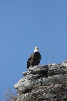
“So”, you ask, “What about the eagles?” OK, I’m getting there. For me, my first eagle sighting many years ago was an awakening of my spirit. I don’t understand completely why but I am captivated by their majesty. The desire to capture that spirit in pictures really opened me to photography as a compulsive artistic drive. Once I had a soaring American Icon in my viewfinder, I was hooked. But my tools were far exceeded by my desire to get that perfect image. I wanted images that I could share with others so they too could experience the feeling I got capturing the marvelous raptor in my camera. Each year brought a little better camera or lens. My weapon of choice now is a Canon D7 with a 400mm “L” series lens combination. This is about as far as I can go without another mortgage on the house. At this point I would need to go from thousands of dollars to tens of thousands. With retirement just around the corner, that jump will probably never come. Fortunately, at this time in life, I have come to grips with this drive for the biggest toys because no matter what you get there is something just a little bigger, a little better. I am ready to accept that fact and simply do the best I can do to learn how to use the tools I have.

OK, OK, I’m getting there. Eagles are basically fish eaters. Sure they will, on occasion take a duck on the river or a rabbit in the field but they nest and usually hunt on the rivers. As winter starts to swallow up the open water in the north, the eagles will start migrating south for food. Around here, they are found as they migrate along the Mississippi and Illinois rivers. They need open water to feed so as the river freezes, they are drawn further south. Along their journey, they will often stop at the Locks and Dams along the river because the water rushing through the gates or turbines won’t freeze. This provides them with the open water to fish. For than reason, they will congregate in large numbers at these locations. It is not unusual to see 25 – 30 in a single tree. Sometime even more when the river is nearly all frozen. But in the event of warmer weather, the river is not frozen over as much and they will spread out along the river due to the lower competition. There are probably as many eagles in totality but they are not bunched up. That has been the case the last couple years.

There is one favorite place along the Mississippi that attracts photographers from all over the country. That sweet spot is Lock and Dam #14 in northern Illinois near the Quad Cities. What makes this spot so special that it draws crowds all winter, is the configuration of the river. There is a small bay where stunned fish can often be seen floating on the surface. The eagles find this a perfect hunting grounds and the near-by observation walk has no visual barriers between it, the water and diving eagles. Every eagle photographer has pictures of  an eagle perched in a tree but to catch a shot of the dive and capture of the fish is the true feather in any nature photographer’s cap. Many can go for many years without the opportunity to make this capture. L & D #14 seems to give the best opportunity to make the capture. Photographers from across the country will line the walkway with $20,000 camera set-ups.

This is a small weekday crowd.

Most of these photographers are from out-of-state. You will notice the buckets by several of the shooters. No it is not to store fish they catch. They are full of fish used to bait the eagles. While some will question the integrity of this practice, it is common here. They will use compressed air in a can to bloat the fish and toss it in the river in hopes an eagle will swoop down for a catch. The eagles don’t seem to mind the easy pickin’ and the photographers are overjoyed with the results. Many of the baiters are professional photographers who offer “eagle safaris” to the participants. I won’t pass judgement but I will say it works if the eagles are there.

An adult eagles swoops in for the floating fish
one leg catch
Hold on tightly and we are off

One thing I have learned over the may years I have chased the elusive eagles from site to site, is that they are unpredictable. The population can not only change from day to day but hour by hour.  But it is worth the try and the wait when you are rewarded with the above shots.

As the days begin to lengthen, most of the eagle pairs know it is time to head back north to  get the nest ready for the spring hatch. New eagles will be born in the North Country and when winter spreads the blanket of snow and ice over the region again, the eagles will return to our backyard and I will again be able to spend the winter trying to outguess their location. But next winter, we won’t be limited to the all too often cloudy weekends. Next year these same dives will be in sunny locations and the beauty will be multiplied many times as I am able to be seen ever so much more clearly.

Perhaps  by next winter, the above juvenile will have graduated to the adult white head and I will see him in all his splendor.

You can see more of my magnificent eagles at: my Smugmug Gallery Click on the preceding link  to see more.

Quest for the Mighty Eagle

Havana Nature Center
Sunday was the first of our eagle watch tours for this year 2011. We headed up to Havana about 45 miles NW of here. While it had never been very good to us in the past for eagle sightings, I saw a note on Facebook from an Illinois Audubon Society member that told of a significant number of eagles around the harbor on Bellrose Island. As we pulled into the riverfront park, we saw what was a new building to us. It was the Nature Center, new last spring. It turned out to have just what these old folks needed. The riverfront room was surrounded by windows and a full view of the river,  Bellrose Island and the marina. The viewing station was warm and there was food service. Two chili cheese dogs later, we knew this could be a new favorite for us on our eagle quest circuit. The adjoining heated full restrooms so necessary at this age, put them high on our preferences list. There is even a campground there that we will try out in the spring. They are open Tuesday, Thursday and the weekend. Look for them on FaceBook: http://www.facebook.com/home.php#!/pages/Havana-Nature-Center/164528800234746  They even show a count of the eagle sitings for the day.

Here is a tip for novice eagle spotters. We sat there for over an hour and some of the time, eagles were barley visible without binoculars. Then, a couple would fly out of the trees and jostle for a captured fish. We watched an adult sparring with a juvenile for several minutes overhead and then they were gone. So, the tip is: be patient! You can’t just drive up, look around and not seeing anything right there, just drive to the next spot up/down the river. Park and watch. Get out the binoculars and scour the tree tops. Once you spot some watch them for a while. There is no assurance they will leave their perch while you watch but if they do, they could easily fly just overhead and turn somersaults less than 100 ft. away! There are always some shore birds around the park so even if the eagles are hiding out on the far shore, there will still be birds to watch. If you are just learning to capture the winged wonders in flight, it is good to practice on the gulls. They will hang almost motionless in the wind 20 feet away.

 When we were there, we even had entertainment to keep us occupied while the eagles were elsewhere. The lady at upper left, sang and played the guitar. Below is a slide show featuring some of the flights from the day. To start the slideshow, click on the play arrow at the lower left corner of the player below.

Vimeo player: Click here

havana 1 2 11 from Dulany Sriner on Vimeo.

The Hills of Southern MO

Above, you can see our eventual destination, the Current river in southern Missouri.

We like the roads less traveled and as we followed the roads mapped out by the GPS tracking program sitting forefront in the Jeep, we found roads that seemed almost penciled in on the screen. Green vegetation protruded through the cracks in the middle of our lane. I think this would definitely qualify as “a road less traveled”! I should have taken a picture but with only a slight chance someone might be sharing this same road with us and the lack of any type of shoulder, I thought I better not stop in the middle of the road for a shot. The vision of an overgrown 4X4 complete with hunting lights and gun rack, coming up over the hill over yonder made me think twice. I would rather face the bear from an earlier post!
So, just picture a narrow road with only about 18 inches of packed clay bordering the brownish asphalt ribbon. A multitude of cracks were dotted with green weeds often standing 12 inches high; complete with a flower or two. Road kill lay, silenced on the hardroad and the only signs of life were the Ozark red headed eagles, commonly known as turkey vultures. Now, as if by photoshop cut-and-paste, envision two obvious city folks in a relatively clean family SUV towing a dent-free camper down the road. Our camper with the air conditioner sitting on top, not protruding out of one of the side windows, hogged the road bouncing from pothole to pothole. It’s a bit like a scene from Deliverance! Now, you tell me, how do I try to look inconspicuous. Standing the in middle of the road with a large lensed camera, would not be my first choice at fitting in.

That all being said, the anxiety was worth every heart palpitation because the same raw nature surroundings that make this land a bit scary, foremost make it beautiful. The spring fed rivers and streams sparkle in the afternoon sun. The strong contrast between the natural stone river base and the super saturated green river plants looks almost surreal. The warm summer afternoon is made even more enjoyable by natures air conditioning from the chilled natural springs. All this and it is less than 275 miles from home. I think we have rediscovered another addition to the “great camping destinations” list.

Our first choice for last weeks destination was Wisconsin but the parks all reflected that “no Vacancy” sign as I went from park to park on the Internet reservation website. What a bummer; we were looking forward to a nice 5 day long weekend vacation. Then I had a thought. Although this is not a common occurrence, I do have a good one ever now and then. I thought of a destination that Pat talked about often. It was a place from her cherished childhood remembrances. Her Mom took her and her brothers to camp on the Jack’s Fork River at Alley Spring State Park near Eminence MO. This would have been back in the 50’s. We had camped in the vicinity once and had taken a canoe float trip down the river back in the 70’s but we had not revisited there since then. A quick check of the vacancies, indicated one electric site left. There was a bonus! The park was now a part of the Ozark National Scenic Riverways system and was managed by the National Park Service. The “ding” of the cash register went off in my head. National Park equals senior discount with the old Golden eagle pass, now called the senior pass. For those of you who don’t know about this senior perk, it entitles holders a 50% discount. We would be getting water and electric hookups for $10/night. That to me is a bargain. Non-electric sites would be only $7. Even I can afford a week there. This new fact is putting the area even higher on that great campsite list.
As we headed off the Interstate highway system and onto the state and county roads, it became apparent cell service would be severely limited. We imagined the “can you hear me now” commercial that they won’t be making. It would start with the driver, make that passenger for safety reasons, trying to make connections as they drive down the roller-coaster highway. At each hilltop would come, “Can you hear me now?” but before any suitable communication, the car and cell phone operator would dip back down into the black hole reception area. I think they refer to it as the “Dead Zone”. The skit would end with the cell phone caller on top of the hill, climbing a tall Tulip tree, dangling on a high branch by one hand and holding the phone in the other. “Can you hear me now? . . . Great, I needed to tell you want a great ti. . . . . the call is interrupted by the sound of cracking wood. AS the phone and caller fall in slow motion from the tall tree you can hear in a harried voice, “Gotta go; I think I am loosing you!” The scene ends with a thud. Nope don’t think you will be seeing that one. While that might be just a slight exaggeration of my cell experience, you get the idea.
Our campground destination, Alley Spring Park is dominated by the old Alley Spring grain mill. The current building constructed in 1894, was powered by the spring which averages 81 million gallons of water flow every day. The mill was designed to produce wheat flower in an area dominated by corn production. This oversight along with recurring floods made the operation only marginally successful.
There is a short trail around the spring adjacent to the mill and a higher bluff trail which as the name implies ascends up to the ridge of the bluffs to overlook the mill.
Even the upper trail is easy to maneuver. AS some may recall from previous postings, I had armed myself with a new personal GPS unit to keep me on track and make sure the track was the right track and I was going the correct direction. As I started up the bluff trail early one morning, I turned on the GPS for the first time on this trip. I was surprised to find I had no maps for the area. I had thought I had them downloaded from my laptop topography program where I had mapped out our itinerary but I was wrong. When the unit turns on, it brings up the map relating to the new position as indicated by the GPS receiver. At home, it brings up this area. I had not become acclimated enough with the unit to know how to bring up the Alley Spring map without being there. Yes, the preloaded universal map showed major towns and major roads but not anything that was of any benefit to me. Think of a child with a felt marker as they try to draw a map on plain paper. It might just look like a zig-zag line all over the page. No matter how closely you look or how far away you hold the paper, it still makes no sense. That was my GPS screen. I put in map pins to tell me where I left the car and where the trail started and there were the trail markers between them showing my route but nothing else. It was like I was making the map myself. It was cool but not too helpful. I guess I could retrace my route to return to the car but I really expected more. It wasn’t until I returned to the camper and my laptop that I could transfer the scribbles on the map base and see where I had gone. Obviously, I had not brought my original state by state base maps DVDs to upload to the GPS. I was supposed to be able to upload the same thing from the laptop but that too eluded me and after several hours trying to understand the two manuals that I gave up and just was happy to scribble maps. The software program would say “check the GPS manual for directions for downloading” but when I looked at the pertinent chapter in the software program it would say, “consult the GPS manual for downloading instructions. Yes, I admit the DeLorme GPS unit has a steep learning curve as reviewed on line. It wouldn’t need to be so steep if intelligent writers would have written the manuals. Yes, another of my pet peeves!
A major attraction in the area was Rocky Falls, south and east of Eminence. We took a picnic lunch and after hiking up the Falls and higher up to the top of the mountain, Kira and I came back down and joined Pat who had lunch ready at one of the many tables available.
This is obviously a popular lunch spot. I’m sure we will see it again. Throughout our visit back and forth across the area, we saw people of all ages enjoying the water either as spectators or as swimmers or boaters. The cool, often cold waters were cooling on a hot summer day. Most of the water comes from the multitude of springs in the area. It is cold and crystal clear. Drinking the water is not recommended but it sure looks inviting. It was tempting to drink it but we decided to head the warnings.
During our 5 day stay, we saw several different springs. Round Spring was OK but no real Kodak moment here. The nearby cave was closed while they installed new bat gates. I wonder if Batman knows they moved the cave from Gotham City. I was hoping to get to the cave and perhaps pick up some new utensils for my Batman camera belt. I was particularly wanting the bat buckle but I guess I’ll have to wait for that. For those of you who have not been following my many ramblings on this and other blogs and Facebook, I have decided the best way to carry my cameras and gear would be on a utility belt like Batman. I mentioned that I would like to get the Batman buckle. If you know where one can be obtained, let me know. I won’t be getting one at the Round Spring Bat Cave any time soon.
Of all the springs, Blue Spring was my favorite. The super saturated blue is unreal. The clear water allows the viewer to see all the way to the bottom 310 feet down. The statue of Liberty could sit on the bottom and the torch would still be under water. It was difficult to pull away from this place and head back to the car 1/2 mile away.
The Current and Jacks Fork Rivers are known by most nature enthusiasts in Missouri and neighboring states. The attraction is the canoe-ability of the rivers. They are swift moving making float trips a great days event. The numerous easy “white water” passages give additional excitement to canoeurs and those in kayaks. In contrast to the basic mud bottom rivers of the Midwest, these spring fed Ozark riverways with their consistent flow and gravel base make for a great summer vacation.
As we pulled out of the campsite and headed home, I took with me many beautiful memories of sights and experiences. Some of these I was able to capture as pictures while others will be a part of my memory which is unfortunately fading fast. (good thing for the pictures)
I also returned with a bad case of chiggers which I carelessly picked up the last evening and 2.7 pounds which I carefully added enthusiastically at the local eateries. It’s back to no breakfast and salad for lunch. It was worth every pound!
One thing is for sure; I was able to overload each of my senses in a positive way difficult to describe. There is no doubt in my mind; I will return. When I do, I’ll take you along to hopefully enjoy as I do the natural wonders of this beautiful country.
For those of you who follow me on FaceBook, more of this weekend’s pictures will be posted in a FaceBook album.
Until we meet again on those roads less traveled, enjoy the beauties of nature that are all around us.

Facing my own Bear

If you have been following my adventures, you know that I recently faced a bear in the wild while hiking the Appalachian Trail. Last weekend, I had to face my own internal bear. We all have them hidden away. Even Luke from Star Wars had to face his during his training as a Jedi Knight. Now that I have your attention, let’s get started at the beginning where all trails should start.

Our adventures this week took us to Starved Rock State Park in the North-Central part of Illinois. The park is known by the high rock formation where an Indian Tribe was starved out by another tribe. The easily defended location made attack futile but the same isolation that protected them also imprisoned them. They starved on the rock. For many, this group of rock formations were the extent of the park. This extended 4 day weekend, showed me a part of the park that I had never explored before. We spent the time hiking the many canyons along this section of the Illinois River. The weather with recent and consistent rains had kept the many springs flowing unlike most summer seasons. Every canyon had some type of waterfall at the beginning. All were flowing. It was an awesome sight. Above, this picture looks down the river toward the namesake.

We arrived at the campground Thursday around noon and set up camp. We took some time in the car to reorient ourselves to the area. We explored the nearby town of Ottawa and were captivated by the “home town” feel of the business district. Murals could be found on many of the old historic buildings. A central square advertised the location of a Lincoln-Douglas debate with statues and a surrounding fountain. I posted the video on my Face Book page with the caption that this was the location of the debate. Readers were quick to ask if the debate took place in the fountain! I suspect the fountains were an afterthought!

A relaxing campfire and large grilled hamburgers gave way to a beautiful sunset and my version of s’mores. I like one marshmallow and a Hershey square between two Lorna Dunes – yum. What a way to end the day.

Friday morning started with an outside breakfast of eggs and potatoes all mixed up. This “mixed up” turned out to be a precursor of the day to follow. We headed out first thing to the closest mall for a phone charger to replace the one left sitting on my desk at home. Then we headed to Matthiessen State Park just down the road from Starved Rock. Our thought was that these trails would be a bit easier on Pat’s knees. We took a wrong turn at the first “Y”and ended up on the interior “challenging” trail. We got to a water crossing featuring un-level, overturned stepping stones. This led to a quick retreat back up the stairs to the more level bluff trail. Another poorly marked trail divide took us back to the lower canyon trail. While this was not our intention, it was negotiable so we went on to the falls area. Pat stayed back as Kira and I made our way up the water covered trail to the base of the falls. Leaning stairs showed what the long delayed maintenance was doing to the park system. We stepped over the broken steps and made it to the top where we could look down on the low falls and back up the stream to our original destination. The water level made this trail impassible without serious wading. While Kira would love the adventure, I was not comfortable with a $3,700 camera around my neck. Again, we retreated.

Here, I have to tell you a bit about myself. I have always been very self-sufficient. I flourish in challenges but as my body ages, I have begun to feel the unusual-to-me feeling of frustration at not being able to do something. I have always been at home in the woods. I never got lost and a challenging trail was one more thing to conquer. Now, I find myself having doubts. What if I slip? What if I can’t pull myself up? What if I can’t find my way back? So, as I stood at the base of the moss covered wet rock, I chose not to go on.

Our hike back out of the canyon was complimented by the presence of another older couple (probably our age) who had also come down the wrong way. They chose not to go back in the canyon but turned back up the stairs with us. A few hundred yards up the trail, the poorly marked trail that we had missed was off to the right. I decided to take it up above the falls to the lake while Pat would head back with the other couple. Kira and I went up to the lake , took some shots and headed back down to catch up with Pat. As we passed a couple with a dog, all my attention was on Kira who is not always friendly with other dogs and I missed the trail turnoff and we went back down the trail we had just come up. When we got to the stairs, I knew I had missed the turnoff and we turned around to go back up the trail to the missed turn. The anxiety of missing numerous trails and retracing my path numerous times was surpassed by the feeling of good health. I even began to jog up the trail to make up time. This is something I have not done in years even on level ground. I was feeling good and we made up the time and met Pat at the bridge where she was patiently waiting for us.

Below us was a substantial waterfall calling to me. The older couple had gone down that direction and I decided to follow, leaving Pat on the bridge to wait for our return. We headed off to the right side of the bridge and up the trial along the ridge of the canyon. About a mile down the trail, there was a set of steps. I heard someone say there were 130 steps. I didn’t count. At the base of the steps, there was a foot bridge across the canyon and then another set of steps going round and round like a high-rise stairwell. At the base, was the often muddy canyon floor. We headed up the canyon to the base of the falls and took our pictures. It was worth the walk. High above, Pat stood waving from the bridge above. (click on picture to see larger version) I soaked in the energy of the falling water. It is the closest thing to ocean waves. There is such power. The trip back up the canyon was a little easier as I knew where to go and how to avoid some of the mud. We reached the stairs. Round and round we went up the 8 – 10 flights of stairs. As we exited the stairwell, I saw the familiar wood steps that would take us the rest of the way out of the canyon. At the top, I glanced over at the map to my left but knew I had to turn right to head back to the bridge. Off we went down the trail. The woodsy trails all look the same so there were no discerning markings but it seemed like a lot further back than it was getting there. We walked on and on thinking the bridge and Pat were right around the bend or behind the trees. They were not. Then I saw a metal gate ahead. I didn’t remember it but it was probably by the turnoff to the bridge. I was wrong again. A sign indicated we were leaving this section of the park. Fortunately, there was a map there. We had gone the wrong way after leaving the canyon. It was a couple miles back to the stairs and then about a mile more to the bridge. AS I tried to quicken my step to hurry our journey, I had to face the fact that perhaps I no longer could trust myself in the woods. Had I not had a map to guide me back the way I came, I would have been lost. I told myself that I couldn’t go into the woods without a GPS unit because I lost track of direction. Was this the beginnings of Alzheimer’s? Would I get lost on the way to the grocery store? While you read this, you might chuckle but I assure you I was not laughing. My Mom has Dementia and the prospect of ending up there is terrifying. There was a lot of soul searching as I walked back toward the stairs and eventually the bridge where Pat waited, frightened by our delayed return.

“You made the loop around, I see” she said questioning. Then I realized I had come back on the left side of the bridge. It wasn’t until that point that I realized what I had done. I had come up on the opposite side of the canyon so my trail back required a left turn not a right turn. Then the pieces started to fall into place. I didn’t remember crossing the foot bridge on the way back. The circular stairwell steps had disoriented me and I was too hyped up on endorphins and adrenalin to properly be aware of my surroundings and where I had come and where I was going.

So, was this a premonition? A warning? or an early symptom? I don’t know. Should I invest in a handheld GPS? Probably. Did my concern and attention directed toward Kira throw my senses off? I don’t know.

I forced myself back on the trail alone that afternoon for some needed self confidence and I didn’t get lost. Another hike Sunday morning also resulted in success but I was fortunate enough to have another couple to guide me over an unmarked trail after we ventured to the upper falls above Illinois canyon. Had they not been ahead of me on the trail, I probably would have stopped and retraced my path back to the familiar canyon floor. I lost something that day. It was the self confidence I always have had in the woods. If you see me wandering aimlessly at the reunion, just point me back to the food table.

I’ll be researching a hand held GPS very soon. After a quick search, I ordered a new handheld GPS unit. I’m not taking any chances. Perhaps this unit will have the meat section at the grocery store as a way point.

Next post, we will be finishing up our adventures in Shenandoah National Park where we hike to one of the many waterfalls. See you then. Assuming I can find my way back to this computer.

You can find more Starved Rock pictures on my FaceBook page.

Bears – Up Close and Personal

The State Journal Register featured an article of my bear encounter in today’s edition. That story was based on an interview with me and on the following recount of my experience. I want to thank Chris Young for his article. It was excellent as usual. If you are a nature enthusiasts but not local, I encourage you to follow him on the web . http://www.sj-r.com/ One correction I might make for those in the Springfield area, I am semi-retired, but I no longer do home inspections. I am the House Doctor and specialize in home repairs and remodeling. That’s what pays for the camera equipment! Am I a professional photographer? That depends on your definition of professional. Do I take and sell pictures? Yes. Do I make enough to cover expenses? No. If you are interested in seeing more of my work, go to http://www.dsdigitals.com/ . Now let’s get on with the story.

It was about 4 PM local time. My wife and I were camped in Big Meadows Campground in Shenandoah National Park. The weather was clear that day and I had spent the morning hiking down the trail to Dark Hollows Falls. We had experienced lots of fog and rain during our stay in the park so I wanted to make the most of a rare, rain free day. I topped my monopod walking stick with a simple digital Canon Powershot A590. The camera backpack was lightened up so I could travel quickly and return before dark. Inside the bag was my Canon 5D Mark II with a 28-135 mm zoom lens. The heavy telephoto zoom was left behind.

I started out on a section of the Appalachian Trail behind the campground (at right) and quickly turned onto the Lewis Falls Trail to descend about 800 feet down to the observation point at the falls level. Alone on the trail, it was easy for the mind to visit many places as the feet seemed to negotiate the rocky trail on their own.

At right, Kira and I are on another portion of the Appalachian Trail the day before.

While thoughts come and go, I think every hiker in bear habitat area has to come to terms with the thought that some day they will encounter a bear on the trail. Just the day before, my wife and I talked about the possibility and we decided our best option was to display as large an intruder as possible. I say intruder because that is what we are; we’re intruders in the bears land. We thought we would stand side-by-side with arms outstretched making loud noises. Once you come to grips with the possibility, it is time to move on to other more pleasant thoughts. On this trail, I knew I was venturing into the active time of the bears as dusk would be approaching soon. I also knew I was alone, possibility not the best idea but my only option at this time because my wife’s knees would no longer support her on a long hike particularly where a climb is included.

Each step resonated though my body as my feet hit the large sharp rocks making up most of the decent. Clomp, clomp, clomp down the trail I went. “A noisy hiker is not likely to startle a bear”, I kept thinking to my self. At times I considered whistling or singing but I knew I was overreacting, over thinking this whole bear thing. About half way down the trail, there in the center of my path was a large pile of Bear Dung! It wasn’t still steaming but it did look fresh! It doesn’t take an Indian guide to recognize bear dung. IT IS BIG! Was this a warning or an omen? My wondering mind was quickly brought back to the here and now. I reasoned that I would be just as likely to encounter a bear if I turned back as I would if I went on to the falls. I stepped over and headed on down the trail. I did take extra precautions to be more aware of my surroundings and possible trail mates, the hairy variety!


When I reached the falls overlook, I caught up with my first fellow hiker. Some how, this gave me a feeling of security. We exchanged pictures and headed down the trail to the observation point below. I lingered at the falls and again found myself alone. Another group then joined me and we headed back up the trail together. They were younger, so I was falling further and further behind and about half way up, our trails split as they headed up the easier fire road and I cut back onto the Appalachian Trail to head back to the campsite. I had figured 1 hour down, one hour at the falls and 1 hour back. This would put me back at 7 PM local time; prime bear time. I was ahead of schedule as I headed, again alone, back toward the campground. This part of the trail was not as rocky as I had completed most of the climb. The monotony of the trail now started releasing the leash on my thoughts and they began to wonder. I was breathing in the fresh air, and absorbing the pure vibrations of nature. The endorphins were flowing and I was on a nature high.

As I approached a bend in the trail, the endorphins were replaced by adrenalin. There less than 20 feet away was a full grown female bear in all her splendor. At age 63, this was my first up close and personal encounter on a trail. I had played the scenario many times in my mind but this was the real thing. I was there and so was the bear. I stood still as she looked me over. I was doing the same thing to her. All that advice about not making eye contact, I didn’t care what the experts said; I was watching every move she made to judge her next move. I figured if necessary, I would use the walking stick and attached camera as my weapon of choice but hopefully it would not be needed. As I calmed down and started to reason out my next action, I knew that my first action might be the most important decision affecting the rest of my life, short as it might be. I placed my hand around the top of my only weapon and tensed up as I carefully gripped the hand-hold and snapped off a picture! If this was going to be my last picture, it better be a good one! She started in my direction at about a 30 degree angle from a straight line to me. I countered with an advancement along the trail. As I proceeded, I turned to constantly face her as we passed within feet. Sure wish I would have fired off a few more shots but at the time, I was more interested in survival and having the option to see my shots on the big monitor. About 30 yards down the trail, I stopped and took the good camera out of the backpack. It was at this time, I realized there were two cubs playing in the meadow. Momma was more interested in going to them than going after me. Where is that telephoto lens when you need it? I felt too vulnerable to get close enough for any really award winning shots but I sure had a story to tell.

The following picture, while taken the day before with a 400mm lens, exemplifies what I saw when she came out of the brush and crossed the trail ahead of me. By the time I fired off that first shot, she was walking away.


With shadows ever lengthening, I headed up the trail knowing I had passed the bear test. I had cell service on this side of the ridge so I took the opportunity to call my daughters and let them know that dear OLD Dad had passed the bear test. I kept looking back to be certain Momma bear had not decided to follow me home for dinner; hers! I remember laughing over the phone saying that she had probably told her brother and his friends about the encounter and they would be waiting for me in the parking lot at the end of the trail. I could see them standing around in a semi-circle with chains and clubs and wearing leather vests with gang symbols on them. We laughed, Kim and I, not the bears, as I walked back to the camper to tell my story to anyone who would listen.

We all have our bears to face in life. I prefer to face mine with a smile on my face and a hardy laugh to let the bears know I am coming.

The Appalachian Trail

The Appalachian Trail extends for about 2,175 miles, starting from Springer Mountain in Georgia and going to Katahdin Maine. There is an International A.T. that extends up into Canada to the end of the mountain range where it enters the North Atlantic ocean. Now at the semi-advanced age of 63, I can say I hiked the Appalachian Trail. I didn’t start exactly at the beginning in Georgia although I encountered several along the trail that had. And I must further admit, I did not make it all the way to the North Atlantic. In fact, I didn’t even make it through Maine. It is hard to say how many miles I did go because I made two different attempts at different times. Both attempts started near the middle in Virginia and one headed north and the other south.
My first attempt started at the Big Meadows campground near Shenandoah Virginia. My wife, Pat and dog Kira joined me on this particular adventure. We made camp at the campground and got up early in the morning to get an early start. The trail actually skirts a portion of the campground so it didn’t take much time to get to the trail and head toward our first destination, Fishers Gap. The skies were cloudy and a bit cool. I started with a sweatshirt over my regular shirt and then wore my photographer’s vest over that. It was comfortable in the early morning moist air. I was carrying my Canon 5D with two lenses and miscellaneous accessories in my vest. Pat was similarly dressed without the vest but with a jacket. When embarking on long cross country trails, it is important to dress in layers to be shed as the sun warms the trail. Kira, our new canine companion was secured with a long retractable leash so she could scout the trail ahead and bark if there were any bears along the way. Pat and I decided that if we did encounter a bear, we should stand side-by-side to look bigger and a more worthy adversary.

The trail was well marked with occasional concrete posts and numerous painted bars on trees along the way. The flashes were color coded to mark different trails as there are many shorter trails that criss-cross the A.T. The posts showed the AT symbol along with distance notations on the metal strap that went around the post. ( Like all pictures on this blog, the above picture can be enlarged to see the strap markings. Simply click on the picture.) Each side marked distance with direction arrows. This post (above) showed the first destination at a mile. It is much easier to go from destination to destination only a few miles apart than it is to look at the total distance you plan to go in a day, week, or month. We were a little out of shape so we didn’t plan to go more than 20 miles the first day. But for now, it was just that next post we would be looking to see. You should be seeing a picture now of two hikers unprepared for 100’s of miles of rugged trails.

Wildlife along the trail was plentiful; especially the deer. They seemed to enjoy posing for pictures. They were also fascinated by Kira who did not bark at them. They even walked up toward her when we were on walks in the campground.
The trail along this section was a easy downward grade and all but the steep sections were smooth. On the slopes, the soil is washed away to expose the grapefruit sized sharp rocks that make up the walking surface. As the sharp points pressed into my worn sneakers, it reminded me why we got steel shanked hiking boots for our trail hiking in the Rockies above Estes Park CO. I made a mental note to buy a new pair before I did much more mountain hiking. We were not traveling very fast because Pat has problems with her knees and the uneven pathways made hiking difficult and rapid travel painfully impossible. The only thing that might quicken her pace would be the sight of a bear. Did I mention this is bear country? And bear sightings are common on the trails? You are probably saying to yourself, “What are they thinking? They are not ready for even a week on the trail. “

The first thing we noticed on the trail was the saturated color all around us. Ferns covered most of the forest floor and it resonated the color green. It is said that green is a very soothing color and it was. My euphoria was interrupted by Pat’s question, “How far do you think we have gone so far?”

My quick answer was, “About 1/2 mile.”
“Are you sure that is all?” she replied in a hesitant voice.
The trail was beginning to descend more quickly now as we walked on. Have you ever ridden in an old car with worn out shocks? Old knees are a little like that. There is little bounce as your foot hits the hard rocks on each descending step. I looked back and knew Pat was in pain! Fishers Gap would have to wait for another try. It was time to turn back toward the comforts of the camper and an easy chair while we sipped a cold drink and planned the next trail to conquer.
As we headed back up the trail, the clouds began to thicken rather than clear. The fog was now rolling up the side of the mountain. The foggy tendrills were almost like the serpent tongues of a fire devouring everything in its path. The humidity felt wet on the skin and our layers of clothing were trapping the heat we generated as we climbed up the now ascending pathway. Sweat began to form but could not evaporate in the moist mountain air. Remember the layers of clothing? We had too many and began to shed them as a snake sheds it’s skin.

There was a eerie beauty of the fog as it would ebb and flow. One minute it was difficult to see each other and other times it was as clear as a cloudless day. According the time stamps on the pictures, we had been hiking about an hour and a half. We had probably gone just less than two miles but remember it is climbing and descending. Did we really expect to go 20 miles in a day? Get real! WE knew from our hiking experience in the Rockies that a 6 mile round trip is a long trail! While our journey was short, we could now say we had hiked the AT. What a rewarding experience.

Now, where is our camper? I know we left it here?

Shenandoah National Park


It was Saturday morning, June 11th. We were packed the night before and ready to pull out. I attached the camper, loaded the final gear and put our new canine companion in the car and we were off. Now, if you are thinking I forgot to put Pat in the car, I figure she was on her own and she could get herself strategically placed in the copilot’s seat. She was in charge of navigation which according to her job description included not only telling me where to go and how to get there but she also felt compelled to remind me of speed limits and my current speed. Other duties included monitoring the distance between me and the next car and any indication of brake lights ahead . . . . for miles!

Our first stop was a KOA just inside the West Virginia state line on I-64. There was a time when a 13 – 14 hour drive was normal for the first day of vacation. Those days are gone. We spend that much time just stopping at bathrooms. Love these Golden Years! With the camper in tow, the mileage was averaging about 10 – 12 MPG. With a 20 Gal tank, it seemed we were stopping every hour to either fill or empty the car or ourselves. Too bad we couldn’t synchronize to do them at the same time! By the end of the day, we were in the beginnings of the mountains. They are so beautiful but also stressful as we tried to get up over 30 MPH on some of the inclines. The old six cylinder Jeep was doing her best but when you have your house attached to your rear bumper, you can finally empathise with the slow moving tortoise as the Rabbits and other car models whizzed past. I just had to hope they were out of the way when we hit the downhills! It gives new meaning to roadkill.

We pulled into the campground before dark and got a pull-through site and didn’t even disconnect. We plugged in the camper so we could have the air conditioner and microwave but other than that we were self reliant.

KOA’s are usually pet friendly. This one even had a playground for Kira our new German Shepherd dog. She was a real trooper on this trip. We got her as a stray two weeks before vacation and she fit right in. She not only travels well but she behaves in the camper. We could not have asked for a better traveling companion.

Sunday morning we were off by 7 AM and headed deeper into the mountains. The ascending grades became steeper and slower. We decided although we love our Jeep, we might be considering a different tow vehicle for future mountain trips.

AS we drove through Richmond Virginia, Pat took this picture of their capitol building through her window. It was beautiful. Had I not been pulling a trailer, I would have stopped to take a better picture.

We crossed most of Virginia and headed northeast along Skyline Drive toward our campground, Big Meadows.
Above, the picture “foggy conditions ahead” would be an indicator of the weather for the next week while we were there. It was cool but we had considerable rain and fog.

We were greeted to the campground by the campground hosts, several deer. This would become a normal daily ritual. There was no lacking of wildlife here. The first day we saw, deer, a bear, several skunks and chipmunks. Birds were numerous.

We set up our campsite and settled in for a week in the mountains of Virginia. You can see by the picture that the sun had come out by late afternoon.

Tug Boat Days in Grafton

OOPS! It’s been a long time since taxes. Would you believe I was recouperating? How about procrastinating? I have a neighbor down the street that keeps telling me he has decided to stop procrastinating – one of these days. For me, I guess this is one of those days. I was writing to a good friend in Florida and my e-mail describing the weekend trip was taking on a life of its own so I thought, why not edit it and post it on the blog. Perhaps this will prime the pump and get me back on schedule.

It was Saturday morning and the weather map showed clear skies currently around St. Louis. The key word here is “currently” as we would find out later. But that was all we needed to make the decision. It’s weekend, the sun is shining, the fledglings are long out of the nest so it is time to hit the road.

We headed south to Alton and drove in and out of threatening skies. At Alton, the sky was partly cloudy but there were building storm clouds to the north. White pellicans (black under wings) were enjoying the updrafts as they soured over the river. The darker skies served as a backdrop for their flight.

I got the bird pictures along with the cool bee shots at a wildlife refuge across the river from Alton in Missouri.

As I hiked down to the waters edge, I could hear thunder in the distance and saw a few lightning strikes. I was making the most of the sunny skies to capture the numerous white pelicans, egrets and blue heron. Below right, you can see the open wings on one of the pelicans; notice the black underside (click on the image to see it larger)

We then headed north along the great river road from Alton to Grafton. We drove into rain making a cool picture opportunity of the bluffs on the right and the river on the left but the picture through the windshield was not good enough to even keep. There was traffic on the road and the heavy rain made it impossible to stick the camera out to get the shot. If I had been able to get perpendicular to the view, I could have lowered the window and shot through the rain from inside but the only shot was through the windshield. So, this was one of those that “got away”.

Along this road, is a small town called Elsah that is nestled between the bluffs. We can’t drive this stretch without taking the detour through the town. Two one-way streets take you to the end and back past the small quaint residences. It is like a storybook land with the tiny cottages. It is an uplifting experience making the short drive. It was nearing lunch time and our favorite restaurant was in sight. The rain had let up and there was a parking spot near the door. Memories of past visits grabbed onto our senses and pulled us in. OK, there was not much pulling necessary. Even thinking about the home made pie makes my mouth water. WE got a nice salad to be “good” because we knew we would be getting pie, which was hardly on our diet. The salad was so filling, there was no room for pie but I had a solution for that! Make that pie to go!

Back on the road, we drove out of the rain and the pavement was dry. Wow, what luck because we were just pulling into Grafton to check out the Tug boat days. Advertisements called for tug boat tours and an antique boat show. The dirt parking lot showed no signs of rain. We got a close parking spot and I loaded up my gear into my photographers vest and we headed for the tug boat tour line. Just as we got under the canopy, the skies opened up and the rain started. Scattered thunderstorms just scattered themselves our way. I made certain my telephoto lens was securely covered in one of the big pockets and I pulled the vest up over the camera hanging from my neck. This is one of those decision times. Do we head back to the security of a dry car or take our chances at getting the camera equipment wet in the hope of getting some spectacular shots from inside the tug boat. This is one of those times a good pocket camera would come in handy!

The rain let up to a sprinkle so we stayed in line and ventured out from the protection of the canopy onto the tug boat deck. The 25 year old tug looked like it just came out of the boat yard with a new coat of paint on the slippery deck. The wet deck makes me wonder why they don’t use a sand finish but there are ample railings to hold as you traverse the boat.

And traverse we did. From the galley and the lower engine room, we headed up to the Texas deck and then up a narrow inside stairway to the wheelhouse. Windows all around give the captain the full view of the tugboat and electronic monitors show weather, water depth, GPS maps and other boat traffic. It is a log way from the “mark twain” called out as the leadsman from the past measured the river depth.

This tug boat was one of the larger river tugs. It normally pushed barges up and down the lower Mississippi where there are no locks. It might have 30 barges in tow. That makes for one long boat. It takes great skill to maneuver such a large vessel between bridge supports and around bends in the river. Above St. Louis, where there are many locks on the Mississippi and Illinois rivers, a normal load might be 15 barges. This is still equivalent to 870 Semi-trucks. It is by far the more efficient transportation method. For more information on the need to modernize the river lock system visit http://www.marc2000.org/ . If you would like to work on a tug boat go to http://www.ingrambarge.com/ . I can’t say it’s not tempting but they might want me to do something besides take pictures.

As we left the wheelhouse, descending the narrow wet outside stairs, the rain started again. This time it was more insistent that it would stay around a while. We made it down the stairs, across the deck and down more stairs. I had Pat’s umbrella tucked into one of my pockets but I could not get to it without exposing the camera to the elements so, we carefully made our way across the bow of the boat onto dry land that was now running with water. From tent to tent, we scampered like little mice. I should say old mice because our scamper was more of a shuffle but we made it back to the car and I quickly took out the camera and lenses and dried them off. They were relatively dry so the vest was certainly a Godsend. We didn’t want to wait around for the rain to stop to take the second tug tour, so we headed out, driving past the antique boat show. It was too wet to get out and view those boats so those pictures will have to wait.

A few miles down the road, we pilled off at a picnic grounds in Pere Marquette State Park. It was still raining and even the covered shelters couldn’t provide dry tables, so we got out our pie and ate in the car. I must say it was delicious. We decided we had filled the day as full as we wanted and it was time to punch in “current GPS position to home” on the computer. We headed north along the Illinois River and across the bridge at Hardin. This way we could take the free ferry back across at Kampsville. No trip along the river is complete with out at least one ferry ride.

We made one last stop at Carrollton for pictures of the county court house, one of Pat’s projects, and headed for home. So ends another day in the life of the empty nesters.

Where Eagles Soar

Last year I wrote an article on the magnificent eagles and where and how to find them. I have posted this article on my website. It is in PDF format. Here is a direct link:
https://sriner.com/Where_eagles_soar_with_pics.pdf

I have new eagle pictures from the Grafton IL area that I will share on the next post. I have been working on my taxes, what can I say.

Return of the eagles

As the winter winds brought the cold Canadian air further south into the Mississippi River valley, they also brought the eagles, in search of open waters, down from the North for their yearly fishing trip; eagle style. Warmer temperatures had delayed the migration; but, the recent arctic blasts forced the eagles hasty retreat. Pat and I were ready to continue our yearly ritual of searching out this wonder of nature. So, the quest began!

As I was just reviewing some pictures from Saturday’s outing to Keokuk IA for this publication, I got an e-mail from my wife. Actually it was just a “cc” as she was writing to several family members. It contained the following passage:

“Dulany got out in the VERY cold and snowy weather and walked around “Evergreen Walk” took many pictures, which I am sure he now has downloaded onto his website, if you care to view them. http://em-t-nest.blogspot.com/ If they aren’t up there yet, they will be in the near future. NOTE: look for Keokuk, IA trip.

OK, I get the picture. So, yes dear, here are the pictures you promised.

The pictures she is referring to in her e-mail and pictured here are from the now deserted campus of the old Carthage College in Carthage IL. Carthage College had actually moved to Wisconsin some time ago and the campus had been taken over by Robert Morris College. I will quote from her again:

It was pretty sad to see the buildings in the shape they are in at the present time. However, according to their website www.carthage.edu/ , the new college in Kenosha still has the THE OLD MAIN BELL and The Kissing Rock on their campus. I’ve been to the Kenosha Campus once several years ago, and it is a beautiful campus facing Lake Michigan…So glad they moved on.

It is always nice to go back to see places from your past because it gives a permanence but looking back and seeing it in disrepair is a bit depressing. Sometimes you just can’t go back.

The picture at left tells the story. In the forefront is the limited remains of a broken down tree and behind it stands the street lamp which once lighted this walkway of learning. In the background, stands one of the old buildings as empty as the shell of the tree.

So, there we have the touch with the past. It was a thought provoking end for our Saturday outing.

Now, it is time to move out of the past and on to our quest of the day. If you have followed us on our journeys, you know we are looking for new beginnings not shells from the past and Saturday’s outing was no different. It was the beginning of our Eagle days 2007. We headed out early Saturday morning with Keokuk IA as our primary destination. It was a cold but clear January morning and it was great just getting out to absorb some of the rays through the sunroof.

As we crossed the Illinois River on I-72, we didn’t see any evidence of a mighty wingspan overhead. We had never had much luck there last year and we were glad that we were just passing through. As we neared the Mississippi River, we turned north up toward Quincy bypassing the river at this point; as again, it was not a good spot last year. Keokuk was a new destination for us and we were eager to see what it would bring.

As soon as we crossed the river, we pulled down into the riverside park and there in a tree just off the parking lot sat the object of our quest, the awesome American Bald Eagle. It brings a certain reverence to see them. You can see them in a zoo but it doesn’t have the same impact as seeing them in the wild although the blacktop parking lot next to a construction site was not too wild. Once you crop out all but the sky and this elegant raptor, nothing else seems to matter. I stood almost motionless with glass aimed at the back of his head as I waited for him to turn around for a shot. As you can see at left above, he did turn to me before he flew off. I was there and I got it. What a beautiful shot! If this had been the last shot of the day, I could have been satisfied. I had to think back to our first eagle quests last year with inferior equipment. Now, I was in photo heaven. There was another guy there taking pictures with a small point-and shoot digital and although I’m sure it took good pictures there could be no comparison. I know because I had been there just last year about this time. We talked for a minute after the eagle flew off and I showed him a couple of my shots. “I have to get me a camera like that!” He exclaimed. I knew he was now hooked just as badly as I was.

It was morning so we headed back across the bridge into Illinois so we could travel up the east side of the river with the sun to our back as we looked toward the water. We didn’t see any eagles along there. The one area across the river from our original vantage point was blocked off due to eagle nesting. They didn’t even allow foot traffic.

Our next stop was Nauvoo Illinois, the Mormon settlement along the river. We had been there before but that was before photography was such an important part of my life. We looked around the settlement and came upon a couple missionaries talking to Gary and Gabe, a beautiful pair of Holstein Oxen. We got the complete beginners class, Oxen 101. For those of you who didn’t take “Farm Animals 102”, an ox is a neutered bull. They were used for draft animals because although they were only about 1/2 as fast as a draft horse, they were considerably less expensive. Any Bovine Bull can be used as long as he has horns to prevent the yoke from sliding forward.

Looking back toward town from down here near the river, we could see the Mormon temple rising high into the sky. It was beautiful white and gold sparkling in the winter sun. The two men on horseback in the picture below are Joseph Smith Jr. and his beloved brother Hyrum Smith making their final ride from Nauvoo to Carthage, Illinois where they were martyred. Additional information on the temple can be found at: http://www.lds.org/temples/main/0,11204,1912-1-160-,00.html

After taking shots of the temple from angles on all for sides, we headed north a little more and crossed back across the Mississippi to Fort Madison Iowa. We were now at our furthest point from home as we headed back down the west side of the river toward Keokuk again. We had several sightings of eagles along the way and even saw a couple Great blue herons as we headed back into Keokuk. We pulled back down into the riverside park to get a couple more shots of the many eagles we had seen earlier that morning. There wasn’t an eagle in sight! Good thing we got the shots we did in the morning because this visit was a bust!

Now it was time to head back across the river and eventually back to Springfield after our previously accounted Carthage College viewing.
The timing was good as the snows were starting to swirl around us and temperatures were dropping. A warm meal and cozy fire in the fireplace were looking really good right then.

Thanks for joining us as we traversed the state in search of the beauties of nature and the creations of man on these roads less traveled.

A special blessing to Pat’s brother, Jim and all his family who might have come here to take a look back and recount old memories.

Love and Light,
Pat & Dulany